 Otto Praeger was the second
assistant postmaster general from 1915-1921 and was in charge of the Post
Office Department's airmail service (1918-1927) during its early years. He
butted heads with the service's first superintendent, Benjamin Lipsner, a fight
that resulted in Lipsner's dismissal from the service. Praeger's hard line
towards the pilots helped set a strike in motion in 1919 after he had ordered
pilots fired for refusing to fly in zero visibility fog. The pilots won public
support during the strike and most were rehired. Praeger turned his stubborn
streak toward Congress, battling for financial support for the service.
National Postal Museum, Curatorial Photographic Collection Photographer:
Unknown.
Otto Praeger was the second
assistant postmaster general from 1915-1921 and was in charge of the Post
Office Department's airmail service (1918-1927) during its early years. He
butted heads with the service's first superintendent, Benjamin Lipsner, a fight
that resulted in Lipsner's dismissal from the service. Praeger's hard line
towards the pilots helped set a strike in motion in 1919 after he had ordered
pilots fired for refusing to fly in zero visibility fog. The pilots won public
support during the strike and most were rehired. Praeger turned his stubborn
streak toward Congress, battling for financial support for the service.
National Postal Museum, Curatorial Photographic Collection Photographer:
Unknown.
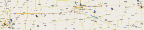
NEW
YORK TO BELLEFONTE
Miles
from New York
Zero. Hazelhurst Field. — Long Island,
N.Y.--Follow the tracks of the Long Island Railroad past Belmont Park- race
track, keeping Jamaica on the left. Cross New York over the lower end of
Central Park.
Hazelhurst Field [40.74N / 073.6W] Was created in
1915 as Hempstead Plains Aerodrome, the airfield was taken over the by the Army
and renamed Leighton Hazelhurst (the first NCO killed in
an aviation accident) when the US entered WWI in the spring of 1917. Camp
Albert L. Mills with two airfields, Aviation Field #1 and #2, were created to
train military pilots. Field #1 was renamed Quentin Roosevelt Field in 1918
after Theodore Roosevelt’s son who was killed in air combat during the War.
After the war the field turned over to the US Air Service who relinquished
control in 1920 but the field remained the New York terminus of the airmail
service.
Because of it’s proximity to New York City,
Roosevelt Field was used for most of the aviation events in the early half of
the century including Amelia Earhart, Wiley Post and Charles Lindbergh’s 1927
transatlantic flight. It was closed in 1951 and became the sight of the first
shoping mall built in the US.
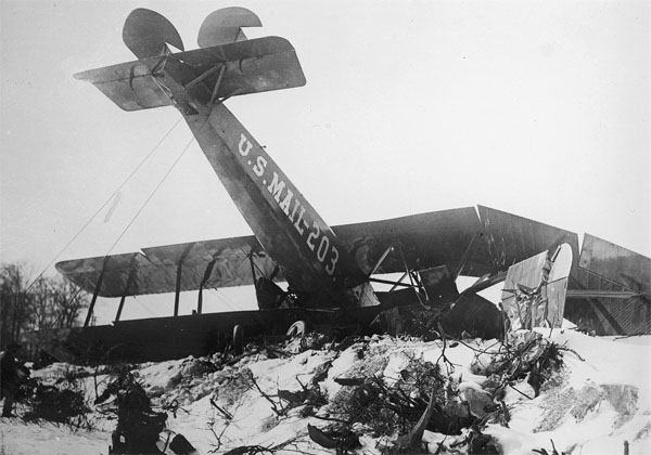 1920 Crash of Martan MP 203 (Skyways Journal Magazine)
25. Newark, N.J. — Heller
Field is located in Newark and may be
identified as follows: The field is 1-1/4 miles west of the Pasaic River and
lies in the New York, Lake Erie & Western Railroad. The Morris Canal
bound the western edge of the field. The roof of the large steel hanger
is painted an orange color.
25. Orange Mountains. — Cross the Orange Mountains over a small
round lake or pond. Slightly to the right of course will be seen the polo field
and golf course of Essex Country Club About 8 miles to the north is
Mountain Lake, easily seen after crossing the Orange Mountains.
50. Morristown, .J. — About 4 miles north of
course. Identified by group of yellow buildings east of the city. The Delaware,
Lackawanna & Western Railroad pass the eastern side of Morristown.
60. Lake Hopatcong. — A large irregular lake
10 miles north of course
64. Budd Lake. — Large circular body of water
6 miles north of course.
78. Belvidere, N. J. — On the Delaware Rv.
Twelve miles to the north is the Delaware Water Gap and 11 miles to
the south is Easton at the junction of the Lehigh and Delaware Rivers. The
Delaware makes a pronounced U--shaped bend just north of Belvidere. A
railway joins the two ends of the U
111.
Lehighton, Pa. — Directly on course. The Lehigh Valley and
Central Railroad of NJ running parallel pass three miles through
Lehighton. The Lehigh River runs between the railroads at this point. Lehighton
is approximately half way between Hazelhurst and Bellefonte. A fair sized
elliptical race track lies just southwest of town but a larger and better emergency
landing field lies about 100 yards west of the race track. The field is
very long and lies in a north south direction.
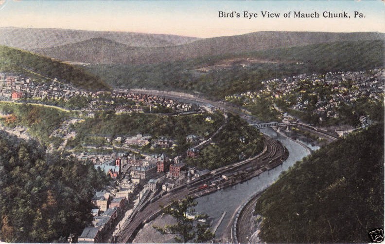 114. Mauch Chunk, Pa.
— Three miles north of Lehighton and on the direct course.
114. Mauch Chunk, Pa.
— Three miles north of Lehighton and on the direct course.
Mauch Chunk PA is now home to the Mauch Chunk
Switchback Gravity Railroad, generally acknowledged as the first roller coaster in the United States. In 1951 The town merged with East Mauch Chunk and renamed
itself Jim Thorpe, PA in hopes of drawing tourists.
121.
Central Railroad of New Jersey. — Two long triangular bodies of water
northwest of the railroad followed by eight or nine small artificial
lakes or ponds about half a mile apart almost parallel with the course but
veering slightly to the south.
148.
Catawissa Mountain Range, which appears to curve in a semicircle about a large
open space of country directly on the course. To the north of the course may be
seen the eastern branch of the Susquehanna. Fly parallel to this until Shamokin
Creek is picked up. This Creek is very black and is paralleled by two
railroads. Shamokin Creek empties into the Susquehanna just below Sunbury.
168.
Sunbury, Pa. — At the junction of the two branches of the Susquehanna
River. The infield of a racetrack on a small island at the junction of two
rivers furnishes a good landing field. The river to the south of Sunbury is
wider than to the north and is filled with numerous small islands. The two
branches to the north have practically no islands. If the river is reached and
Sunbury is not in sight look for islands. If there are none, follow the river
south to Sunbury. If islands are numerous, follow the river north to Sunbury.
170. Lewisburg, Pa. — Two miles west of
Sunbury and 8 miles north.
174 After leaving Sunbury the next landmark
to pick up is Penns Creek. Which empties into the Susquehanna 7 miles south of
Sunbury. Flying directly on course. Penns Creek is reached 6 miles after it
joins the Susquehanna 7 miles south of Sunbury.
178. New
Berlin, Pa. — Identified by covered bridge over Penns Creek.
185. The Pennsylvania Railroad from Lewisburg is
crossed at the point where the range of mountains coming up from the southwest
ends. The highway leaves the railroad here and goes up into Woodward Pass,
directly on the course. A white fire tower may be seen on the crest of the last
mountain to the north on leaving the pass.
202. The next range of mountains is crossed through the
pass at Millheim, a small town. A lone mountain may be seen to the south just
across the Pennsylvania tracks.
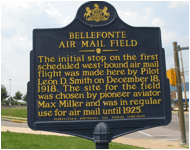
217. Bellefonte, Pa.
— After crossing another mountain range with a pass Bellefonte will be
seen against the Bald Eagle Mountain Range. On top of a mountain, just south of
a gap is the Bald Eagle Range at Bellefonte, may be seen a clearing with a
few trees scattered in it. This identifies this gap from others in this range.
The mail field lies just east of town and is marked by a large white circle. A
white line marks the eastern edge of the field where there is a drop of nearly
100 feet.
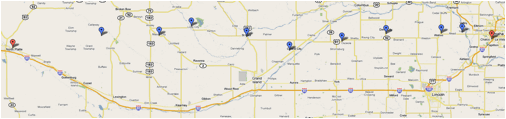
BELLEFONTE
TO CLEVELAND.
Miles from Bellefonte
BEL
+ 0. Bellefonte, Pa. —
Compass course to Cleveland approximately 310. Fly directly toward and over
bare spot on mountaintop south of gap in Bald Eagle Range. First range of
mountains.
BEL + 3. Pennsylvania Railroad,
following course of Bald Eagle Creek.
BEL + 17. New York Central Railroad,
following course of Moshannon Creek.
BEL + 35. Clearfield, Pa. — On west
branch of Susquehanna River. A small racetrack here serves as an emergency
landing field. Two railroads, one from the north and one from the east, enter
Clearfield and both go south from here.
BEL + 55. B. & M. Junction. — One
branch of the Buffalo, Rochelle & Pittsburgh from the east forms a junction
here with the N. & S. line of the Buffalo, Rochelle & Pittsburgh
Railroad. Dubois is 2 miles north of course on the N. & S. line of the
railroad.
BEL + 70. Brookville, Pa. — One mile
north of course, west of city, is 2-mile racetrack, which makes an excellent
emergency field.
BEL + 86. Clarion, Pa. — One mile north
of course. Emergency field marked by white cross and red-brick hangar is here.
The Clarion river passes north edge of city. Railroad from the east ends here
BEL + 110. Franklin, Pa.-Seven miles north of course
at junction of Allegheny River and French Creek. Cross Allegheny River where
there is a pronounced horseshoe bend. This is due south of Franklin.
BEL + 122. Sandy Lake, PA. — Two miles north
of course. Cross the Pennsylvania Railroad at right angles 2 miles south of Sandy
Lake.
BEL + 138. Shenango. — Two miles north of
course. Three railroads enter this town from the north. Two continue south and
one runs east for 3 miles and then turns southeast.
BEL + 152. New York Central Railroad - running north
and south. One mile north of course the Erie crosses the New York Central at right
angles. Four miles west of Erie should be crossed where it turns southward.
Eight miles south of course is Warren with eight railroads radiating out.
BEL + 157. Pennsylvania Railroad, running north and
south.
BEL + 165. Baltimore & Ohio Railroad, Running
diagonally northeast-southwest.
BEL + 206. Cleveland
on Lake Erie. — The mail field is in East Cleveland between the two
railroads that follow the lakeshore. The field is near the edge of the city and
near the edge of the freight yards of the New York Central. The field is
distinctly marked by long cinder runway. The airmail hangar is in the southwest
corner of the field. The Martin factory is in the northwest corner of the
field.
CLEVELAND
TO CHICAGO
Miles from
Cleveland
CLE
+ 0. Martin Field, Cleveland.
— Fly a little west of south for nearly 10 miles or about seven minutes
flying and then due west, thus keeping over good emergency landing fields. The
country between Cleveland and Chicago is divided into sections, section lines
running due north and south and east and west. For the first 15 miles the lake
shore is only a few miles north of the course.
Martin Field - 16800 St. Clair Ave,
Cleveland Ohio. Behind the Glenn L.
Martin Co aircraft plant.
CLE + 20. Elyria,
Ohio. — Five miles south of course. Five railroads radiate out of Elyria.
CLE + 37. Vermilion,
Ohio. — Two miles north of the course. On Lake Erie. The New York Central
Railroad follows the shore line of the lake from Vermilion to Sandusky.
CLE + 55. Sandusky,
Ohio. — Five miles north of the course on Sandusky Bay, a large irregular
body of water crossed by the New York Central Railroad. Continues due west from
this point, following the east-west section lines.
CLE + 112. Maumee
River. — which you cross about 5 miles northeast of Grand Rapids and 5
miles south of Waterville. Waterville is on the east bank of the Maumee and
Grand Rapids is on the south bank of the river where it turns east and
parallels the course for 7 miles.
CLE + 130. Detroit,
Toledo & Ironton Railroad, crossed at right angles. Wausen [Wauseon], Ohio
is 7 miles north of the course and Napoleon is 5 miles south, both on the
above-mentioned railroad. By flying about 11 miles north from the point where
the Maumee River is crossed and then due west the New York Central four-track
railroad will be picked up just before reaching Bryan.
CLE + 152. Bryan,
Ohio is located on the south side of the New York Central tracks, where they
are crossed by the Chicago & North Western and Northern Railroads. Landing
field with hangar and T cinder runway is north of town. Field is two-way, 2,000
feet east and west. Best approach from the east.
CLE + 172. Hamilton
Ohio. — Two miles north of course and 4 miles north of Bryan. On the
extreme south end of irregular-shaped lake. The Wabash Railroad runs to the
south of Hamilton. By keeping the Wabash Railroad in sight for the next 125
miles, you will come in sight of Lake Michigan.
CLE + 196. Walcottville,
Ind. — At the intersection of the Wabash and Grand Rapids & Indiana
Railroads.
CLE + 220. Goshen,
Ind. — Three miles north of course. The Chicago & St. Louis Railroad
is crossed at right angles 3 miles south and 1 mile east of Goshen.
CLE + 243. South
Bend, Ind. — Seven miles north of course. The Chicago & St. Louis
Railroad is crossed at right angles 7 miles south of South Bend.
CLE + 265. La
Porte, Ind. — One mile north of course. The New York Central Railroad
running east from La Porte parallels the course to the lower edge of Lake
Michigan.
CLE + 289. Crisman,
Ind. — Coaling station with large black coal chute north side of track;
has also large race track with course 3 ½ miles north and 1 ½
miles east. Baltimore & Ohio Railroad crosses Wabash at Crisman. Leaving Crisman
fly westerly, following shore of the lake, but keeping about 10 miles from
waters edge to insure safe emergency landing.
CLE + 314. Lake Calumet. — Largest and most
westerly of three lakes. From northern extremity of Lake Calumet fly northwest
on compass course of 315˚ Ashburn Field comes into view to the west and a large
gas reservoir to the east. A large drainage canal will be seen ahead. To your
left, where the Des Plaines River enters the drainage canal, the canal makes a
45˚ turn to the south. Follow the Des Plaines River for about 10 miles and you
will see a large hospital and old race track. This is the speedway and adjoins
the air-mail field on the west.
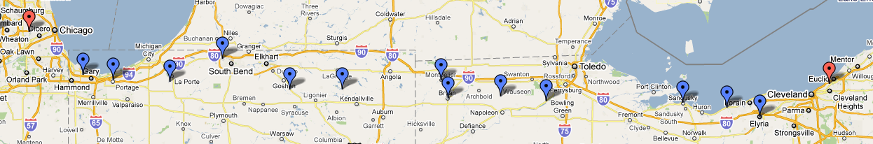
CLE + 330. Chicago
air-mail field or Checkerboard field. — Three large air-mail hangars in
southwest corner of field and private hangar in northeast corner. Four-way
field, but best approach from the south. Telephone and high-tension wires to
west and wires and trees to east of field. Land on large cinder runways.
Sewage-disposal plant with excavations on west side of field. Landing area of
this field large and ample. Telegraph and post-office address of this is
Maywood, Ill. Field is 14 miles west of Chicago post office.
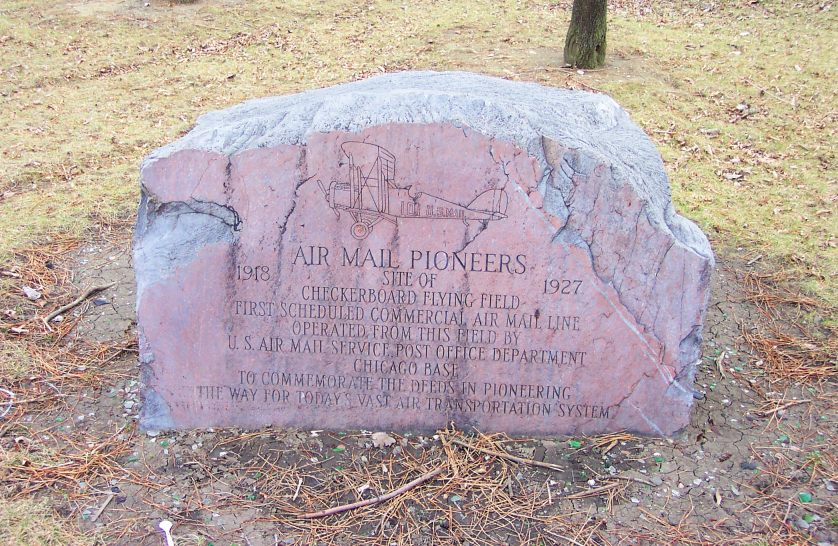
INAUGURALL FLIGHT - FEBRUARY 1922
Four different planes participated in the first
day-night transcontinental flight on February 22, 1922 (George Washington’s
Birthday after the US adopted the Gregorian calendar in 1752), two each from
New York and San Francisco.
Of the two New York-based flights, one was forced
down shortly after takeoff and the other landed at Checkerboard, only to be
grounded by a snowstorm.
The first pilot from San Francisco crashed and died
in Nevada but the second made it to North Plane, Nebraska, where a relay pilot
named James H. ("Jack") Knight took over. Knight left North Plane at
7:50PM and arrived at Omaha, Nebraska at 1:15AM, where he found that his relief
pilot had been snowed in Chicago and had never made the flight to meet him at
Omaha. Knight decided to continue on himself and fly the 435 miles to Chicago
despite the fact that the Midwest was getting blasted by the fiercest snowstorm
they'd seen in years.
 Since the Des Moines refueling stop was also shut down due to
the weather. Knight was forced to an alternate site in Iowa City which had also
closed down once they had heard that the relay flight from Chicago had been
canceled. Fortunately, the Iowa City night watchman was able to guide Knight to
a safe landing just as the plane's fuel ran dry.
Since the Des Moines refueling stop was also shut down due to
the weather. Knight was forced to an alternate site in Iowa City which had also
closed down once they had heard that the relay flight from Chicago had been
canceled. Fortunately, the Iowa City night watchman was able to guide Knight to
a safe landing just as the plane's fuel ran dry.
While
his plane was being refueled, Knight ate a donut and drank some coffee. He
wasted no time and took off into the driving snow as soon as his plane was
ready; he arrived at Checkerboard at 8:40AM, proving once and for all that
day-night coast-to-coast service was indeed feasible.
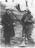
James H. ("Jack") Knight
http://www.franzosenbuschheritageproject.org/Histories/Checkerboard%20Field/Checkerboard%20Air%20Field_expanded%20version.htm
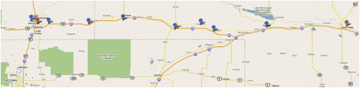
CHICAGO
TO IOWA CITY
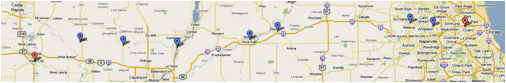
Miles from Chicago
CHI
+ 0. Maywood, Ill. —
Checkerboard field. Fly directly west, picking up the third railroad to the
north of the field. This is the Chicago & North Western. By keeping on the
section lines and flying directly west this railroad can be kept in sight at
all times until Iowa City is reached. It has white ballast and is
doubled-tracked.
CHI + 14. Wheaton, Ill. — Directly on
course. Town rests in elongated U formed by Chicago & North Western
Railroad. Water tower serves as a landmark.
CHI + 24. Geneva, Ill on the Fox River.
— One mile north of course. Two branches of the Chicago & North
Western cross each other here at right angles.
CHI + 84. Dixon, Ill. — Three miles
north of course on Rock River.
CHI + 96. Twin Cities of Stirling and Rock
Falls. — One on each side of the Rock River.
CHI + 130. Mississippi River. — The
Mississippi River should be crossed about 6 miles below Clinton, Iowa, which is
on the west bank of the Mississippi. Flying in the same direction, the
Wapsipinacan [Wapsipinicon] River will show up soon after crossing the
Mississippi. The Wapsipinacan empties into the Mississippi a few miles south of
the course. Fly in the same general direction with this river in view for 24
miles. The Chicago, Rock Island & Pacific runs in the same general
direction as this river and is never more than 3 miles from it until Dixon,
Iowa, is reached.
CHI + 154. Dixon, Iowa. — One mile north
of the course and 1 mile west of the Wapsipinacan River,
which turns north at this point. Dixon lies between the Chicago, Rock Island
& Pacific and the C. N. W. & St. P., which cross about 1 mile east of
Dixon.
CHI + 173. Tipton, Iowa. — Five miles
north of the course. Soon after Tipton is reached, Cedar Rapids will be
crossed. The Cedar River flows southeast at this point.
CHI + 191. Iowa City, Iowa. — On the
eastern bank of the Iowa River. The Chicago Rock Island & Pacific has four
lines running out of Iowa City. The air-mail field is south of town and on the
western bank of the river. The field is small and is longer east and west.
IOWA
CITY TO OMAHA
Miles from Chicago
CHI + 191. Iowa City, Iowa. — On the
eastern bank of the Iowa River. The Chicago Rock Island & Pacific has four
lines running out of Iowa City. The air-mail field is south of town and on the
western bank of the river. The field is small and is longer east and west.
CHI + 215. Chicago, Milwaukee & St. Paul
Railway.
CHI + 233. Chicago & North Western
Railway.
CHI + 240. Montezuma. — Directly on
course on Minneapolis & St. Louis Railway.
CHI + 249. Minneapolis & St. Louis
Railway.
CHI + 253. Minneapolis & St. Louis Railway.
— Short line.
CHI + 255. Minneapolis & St. Louis
Railway.
CHI + 271. Monroe. — Slightly south of
course on Chicago, Rock Island & Pacific Railroad. Three lines out of this
town.
CHI + 296. Des Moines. — Five miles
north of course. Largest city near course between Iowa City and Omaha. Keep the
Raccoon River in sight until about 18 miles out. From here on keep the Chicago,
Rock Island & Pacific in sight. This railroad follows the direction of the
Raccoon River for this distance. The Chicago, Rock Island & Pacific is 2 to
7 miles north of the course.
CHI + 368. Atlantic, Iowa. — Three miles
north of the course on the Chicago, Rock Island & Pacific Railway. At
Atlantic the railroads branch in five directions. If on the course at this
point, that is, 3 miles south of Atlantic, fly nearly due west until Council
Bluffs is seen.
CHI + 413. Council Bluffs, Iowa. — Five
miles east of the Missouri River.
CHI + 418. Missouri River, which is very
irregular in its course and width at this point.
CHI + 424. Omaha, Nebr. — Field is west
of city and can be identified by large hangar with white circle and cross on
roof. North of field is large race track and grandstand. There are two good
approaches, from north and west.
OMAHA
TO NORTH PLATTE
Miles from Omaha
OMA + 0. Omaha, Nebr. — The air mail
field is on the western outskirts of the city, and is 5 miles west of the
Missouri River. The field is rectangular, the long way of the rectangle being
east and west. On the north side of the field is a long grand stand facing
northward and extending east and west. To the north of the grand stand is a
large field with an elliptical race track in it This race track is an excellent
landmark, and the oval may be used for landing if necessary. The west side of
the mail field is bounded by a brook, a few trees, and a railroad track. On the
south the field is bounded by a paved road which ends to the eastward at the
Missouri River. This same road runs due west for several miles beyond the mail
field. On the south side of the field are some high trees and a few telephone
poles. A private hangar is situated across the road from the air mail field
with the word “Airdrome” painted on the roof. The air mail hangar is located in
the southeast corner of the field. The east side of the field is bounded by two
steel wireless towers and a hill covered with high trees. From the northwest is
the best approach, although landings can be made from any direction if made
into the wind.
OMA + 20. The Platte River is crossed at right
angles by flying due west from the Omaha field. By noting section lines the
pilot can determine the correct compass course correcting for drift, as North
Platte and Cheyenne are almost due west of Omaha. For a distance of 70 miles
the Platte River is north of the course never at a greater distance than 10
miles. The Platte River should be crossed between two bridges, one 2 miles
north and the other 2 miles south of the course.
OMA + 21. Yutan. — Directly on the course 1
mile west of the Platte River, 5 lines of railroads form a junction at this
point.
OMA + 33. Wahoo. — A fair-sized town 3 miles
south of the course. Six railroads radiate from Wahoo. An excellent emergency
landing field is located one-half mile south of Wahoo; a smooth barley field
approximately 1 mile long and a quarter of a mile wide. By noting section lines
and flying 25 miles west for each mile south, a direct course may be
maintained.
OMA + 59. David City. — A quarter of a mile
north of the course. Six railroads radiate from this city also.
OMA + 82. Osceola. — Four miles south of the
course. The Union Pacific tracks almost parallel the course from David City to
Osceola, where they turn to the southward. Osceola may be identified by a mile
race track just south of the town.
OMA + 96. The Platte River is crossed again and
runs southwestward. The Union Pacific Railroad is crossed just beyond the
Platte River a half a mile north of the small town of Clarks. Twelve miles
southwest is Central City on the Union Pacific Railroad. This city is 7 miles
south of the course. Central City is directly east of North Platte. If the
pilot passes directly over this city, the east-west section lines can be
followed directly into North Platte. Thirty-five miles southwest of Clarks is
Grand Island in a direct line with Central City. Grand Island is 20 miles south
of the course. At Grand Island there is a commercial flying field where
supplies of oil and gas may be purchased.
OMA + 132. St. Paul, directly on the
course. — Ten miles east of St. Paul one branch of the Chicago,
Burlington & Quincy Railroad runs directly west to St. Paul and lies on the
course. Five railroads radiate out of St. Paul. The Middle Loup River is
crossed 1 mile east of St. Paul.
OMA + 161. Loup City. — Is 5 miles
north of the course on the east bank of Middle Loup River, which is crossed
almost due south of Loup City. The Union Pacific Railroad paralleling the river
is crossed 1 mile east of the river.
OMA + 176. The Chicago, Burlington &
Quincy Railroad tracks following a tiny stream are crossed. The railroad runs
northwest-southeast at this point.
OMA + 183. Mason City. — On the
Chicago, Burlington & Quincy Railroad; is 2 miles north of the course.
OMA + 216. The Union Pacific Railroad,
running northeast-southwest, is crossed midway between Lodi and Oconto; Lodi to
the north and Oconto to the south. A small creek runs through Oconto which
distinguishes it from Lodi.
OMA + 248. North Platte. — After
crossing the Union Pacific Railroad no distinguishing landmarks are available,
but flying west the Platte River will be seen to the south, gradually getting
nearer to the course. The city of North Platte is located at the junction of
the north and south branches of the Platte River. The field is located on the
east bank of the north branch about 2 ½ miles east of the town, just 100
yards south of the Lincoln Highway Bridge. Another bridge, the Union Pacific
Railroad bridge, crosses the stream a mile farther north. The field is
triangular with the hangar at the apex of the triangle and on the bank of the
river. The field, which is bounded on the southwest by the river bank and on
the north side by a ditch, has an excellent turf covered surface always in a
dry condition. The field is longer east and west and the best approach is from
the end away from the hangar. Cross field landings should not be attempted near
the hangar, as the field is narrow at this point. The altitude of North Platte
is 2,800 feet or about 2,000 feet higher than the Omaha field.
NORTH
PLATTE TO CHEYENNE
Miles from Omaha
OMA + 248. North Platte
OMA + 298. Ogallala. — The south
branch of the Platte River parallels the course to this point and the north
branch is only a mile or two north of the course, veering gradually to the
northward. The double tracks of the Union Pacific Railroad follow the course to
this point. Fly directly west from this point, the south branch of the Platte
River and the Union Pacific Railroad, veering to the southward.
OMA + 338. Chappell. — Two miles
south of the course on the Union Pacific tracks and on the north bank of the
Lodgepole Creek.
OMA + 342. Lodgepole. — Directly
on the course between the Union Pacific Railroad and Lodgepole Creek. From here
on to Sidney the course lies over the Union Pacific Railroad tracks and
Lodgepole Creek.
OMA + 360. Sidney. — The Union
Pacific double track runs through here east and west, crossed at right angles
by the Chicago, Burlington & Quincy Railroad running north and south. Two
miles west of Sidney the Union Pacific double track veers to the north, following
the course of the Lodgepole Creek. The course, due west, lies from 4 to 6 miles
south of the railroad and creek for the next 60 miles.
OMA + 395.
Kimball. — Five miles north of the course on the Union Pacific Railroad
and Lodgepole Creek.
OMA + 420. Pine Bluff, Wyo. — On
the Union Pacific Railroad 2 miles north of the course. The railroad and creek
again cross the course, the railroad, turning westward to Cheyenne and the
creek, continuing south for 4 miles and then eastward. The country between
Sidney and Pine Bluff is the roughest on the whole course from Omaha to
Cheyenne, but plenty of emergency fields are found. A ridge extends southward
from Pine Bluff, on which numerous dark green trees may be seen. Two miles
southwest of Pine Bluff the Union Pacific tracks are crossed and for 5 miles
lie south of the course. Then another intersection of the course and the
railroad looping to the northward and again crossing the course at the small
town of Archer.
OMA + 499. Archer Wyo. — A small town on
the Union Pacific Railroad and 8 miles from Cheyenne.
OMA + 458. Cheyenne
Wyo. — Can be identified by the barracks of Fort Russell. The Cheyenne
field is three-quarters of a mile due north of the town and due north of the
capitol building, whose gilded dome is unmistakable. The field, though rolling,
is very large and landings may be made from any direction. A pilot landing here
for the first time must “watch his step,” as the rarified atmosphere at this
altitude (6,100 feet) makes rough landings the rule rather than the exception.
CHEYENNE
TO ROCK SPRINGS
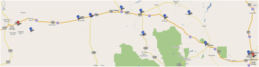
Miles from Cheyenne
CHE + 0. Cheyenne
Wyo. — Fly west over or to the north of Fort Russell, which is about 4
miles from town, following the Colorado & Southern tracks to the point
where they bend sharply to the north.
CHE + 12. Federal Wyo. — The first town
on the Colorado & Southern Railroad after the railroad makes a sharp bend
to the north. Fly about 6 miles south of Federal and leave the Colorado &
Southern tracks about 1 mile north of the pronounced bend. The compass course,
when there is no cross wind, is about 310˚. Cross Sherman Hills or Laramie
Mountains at about 9,000 feet above sea level. Crossing this range of mountains
the Laramie Valley appears where landing fields abound.
CHE + 40. Laramie Wyo. — On the Union
Pacific double-tracked railroad. The largest town in the valley. Pass 6 miles
to the north of Laramie.
CHE + 60. Rock River Wyo. — On the
Union Pacific, 20 miles north of the course. The double-tracked Union Pacific
passes through 2 miles of snow sheds at this point.
CHE + 80. Elk MountainWyo. — To the
north of the Medicine Bow Range, a black and white range of mountains, the
black parts of which are forests and the white snow-covered rocks. Elk Mountain
is 12,500 feet high. Fly to the north of this conspicuous mountain over high,
rough country. The Union Pacific tracks will be seen about 15 miles to the
north gradually converging with the course.
CHE + 114. Walcott. — Cross the S. & E.
Railroad 2 miles south of Walcott. The S. & E. joins the Union Pacific at
this point.
CHE + 134. Rawlins Wyo. — Follow the general
direction of the Union Pacific tracks to Rawlins, which is on the Union Pacific
tracks. The country between Walcott and Rawlins is fairly level, but covered
with sage brush, which makes landings dangerous. Rawlins is on the north side
of the Union Pacific tracks at a point about a mile east of where the tracks
cut through a low ridge of hills. Large railroad shops distinguish the town.
The emergency field provided here lies about 1¼ miles northeast of town
at the base of a large hill. Landings are made almost invariably to the
west. Surface of field is fairly good, as the sage brush has been removed.
Easily identified by this, as the surrounding country is covered with sage brush.
Landings can be made in any direction into the wind if care is exercised.
Several ranch buildings and two small black shacks on the eastern side of the
field help distinguish it. Leaving Rawlins follow the Union Pacific tracks to
Creston.
CHE + 159. Creston Wyo. — A small station on
the Union Pacific is the point where the course crosses the Continental Divide.
CHE + 175. Wamsutter, Wyo. — On the Union
Pacific. Fairly good fields are found between Rawlins and a point 60 miles
west. Fields safe to land in show up on account of the absence of sage brush.
The course leaves the railroad where the Union Pacific tracks loop to the
southeast.
CHE + 215. Black Butte. — A huge black hill of
rock south of the course. The Union Pacific Railroad is crossed just before
reaching Black Butte.
CHE + 231. Rock Springs, Wyo. — After passing
Black Butte, Pilot Butte will be seen projecting above and forming a part of
the Table Mountain Range. This butte is of whitish stone. Head directly toward
Pilot Butte and Rock Springs will be passed on the northern side. The field is
in the valley at the foot of Pilot Butte about 4 miles from Rock Springs. It is
triangular in shape, the hangar being located in the apex. The surface of the
field is good. The best approach is from the eastern side.
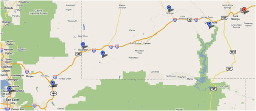
ROCK
SPRINGS TO SALT LAKE CITY
Miles from Cheyenne
CHE + 231. Rock Springs
CHE + 246. Green River, Wyo. — Follow the
Union Pacific double-tracked railroad from Rock Springs. There is an emergency
field here which is distinguished [on] account of its being the only cleared
space of its size, near the town. Green river is crossed immediately after the
city of Green River is passed. Here the course leaves the railroad which
continues in a northwesterly direction. By flying approximately 230˚ compass
course from here, Cheyenne [Salt Lake City] will be reached.
CHE + 258. Black Fork River. — A very
irregular river, which is crossed at right angles. From Black Fork to Coalville
the Union Pacific tracks are from 5 to 20 miles north of the course.
CHE + 282. Granger, Wyo. — 16 miles north of
the course on the Union Pacific where the Oregon Short Line joins the Union
Pacific from the north.
CHE + 330. Altamont, Wyo. — On the Union
Pacific where the Union Pacific approaches within 6 miles of the course to the
north. The railroad passes through a short tunnel at this point.
CHE + 338. Evanston, Wyo. — After approaching
within 6 miles of the course, the railroad turns sharply to the northwest.
Evanston is on the Union Pacific 18 miles north of the course. There is a good
emergency landing field on the southwest side of Evanston, a mile from the
railroad station. From Evanston the Union Pacific tracks curve toward the
course until Coalville is reached.
CHE + 363. Coalville, Utah. — On the single
track Union Pacific running north and south. The single track Union Pacific
joins the double track 4 miles north of Coalville at Echo City. There is an
emergency landing field here a mile east of the railroad and one-half mile
southeast of town. There is a marker on this field.
CHE + 381. Salt Lake City. — From Coalville
the country is extremely rugged and the pilot should maintain at least 11,000
feet altitude above sea level. The field lies 2 miles west of the city on the
north side of the road or street which extends east-west by the Salt Lake fair
grounds. Locate the fair grounds, identified by an elliptical race track and
large buildings. Follow westward along the road just south of the fair grounds
and the field will be reached 1 ½ miles farther on. The field is about
one-half mile long north and south and landings are usually made in one of
these directions. A landing T is used to indicate the proper place to land.
Elevation here is 4,400 feet. High-tension wires border all sides of the field
except the north.
SALT
LAKE CITY TO RENO
Miles from Salt Lake City
SLC
+ 0. Salt Lake City. —
Fly west from Salt Lake, keeping the two railroads running due west from Salt
Lake to the south.
SLC + 12. Saltair. — Near the salt
works there is an open field which is possible for an emergency landing. The
field lies between the highway and the electric railroad that runs into Salt
Lake City. Is rolling and covered sparsely with sagebrush and should be used
only in case of absolute emergency.
SLC + 14. Antelope Island. — In the
Great Salt Lake, 6 miles north of the course.
SLC + 30. Stansbury Island. — In the
Great Salt Lake. The course crosses this island about 2 miles from its southern
edge.
SLC + 45. The Union Pacific Railroad is
crossed where it runs northeast-southwest. Two miles north of the course the
railroad makes a sharp bend and runs southeast-northwest.
SLC + 50. The Union Pacific Railroad is
crossed again. The Union Pacific continues southeast from here for 10 miles and
then turns westward and parallels the course to Wendover. The course is 6 miles
north of the railroad.
SLC + 98. Salduro. — On the Union
Pacific Railroad, 6 miles south of the course. There is an emergency field here
in vat No. 5, marked by a black T. The vat is circular, 400 feet in diameter
and the bottom, composed of white salt, is hard as a pavement.
SLC + 108. Wendover. — On the Union Pacific, 6
miles south of the course. Opposite the Conley Hotel and the Union Pacific
station there is a landing field L-shaped, 1,200 feet long each way and 600
feet wide, a good emergency field. Four miles west of Wendover the Union
Pacific Railroad turns to the north and east and is crossed 8 miles west of
Wendover. The railroad continues northwestward and reaches a northern point 11
miles from the course. The railroad curves and runs southeast, where it crosses
the Nevada Northern, running north-south at Shafter.
SLC + 130.
Shafter. — At the junction of the Nevada Northern and Western Pacific
Railroads. Opposite the Western Pacific station at Shafter there is a stretch
of ground 1,200 feet wide and unlimited in extent the long way, that may be
used for emergency landings. There is a scattering of sagebrush on this field.
SLC + 145. The
Western Pacific Railroad is crossed, running northwest-southeast, after it
makes a loop to the south just beyond Shafter. The railroad veers to the north
until it is 20 miles north of the course.
SLC + 157. Snow
Water Lake. — An oblong body of water 3 miles south of the course. The
long way of the lake extends parallel to the course.
SLC + 170.
Secret Pass in the East Humboldt Range. — The only pass in this range for
many miles. Some peaks in this range attain an altitude of more than 12,000
feet. The northern extremity of the Ruby Range extending north and south lies a
few miles south of the course and is next seen. Then three branches of
Tamoville Creek flowing north to the east fork of the Humboldt River are
crossed at short intervals. The Southern Pacific and Western Pacific Railroads
follow the course of the east fork of the Humboldt River and gradually converge
on the course where all four join at Elko.
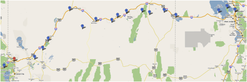
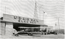 SLC + 204. Elko, Nev. — Lies in the
Humboldt Valley. The air mail field is 1 mile west of the city, with the main
runway east and west. Landings may be made from any direction, although it is
advisable to land east and west. There is a ditch at the east end of the field.
Follow the general direction of the railroad tracks out of Elko, as they run
parallel with the course for several miles.
SLC + 204. Elko, Nev. — Lies in the
Humboldt Valley. The air mail field is 1 mile west of the city, with the main
runway east and west. Landings may be made from any direction, although it is
advisable to land east and west. There is a ditch at the east end of the field.
Follow the general direction of the railroad tracks out of Elko, as they run
parallel with the course for several miles.
SLC + 224.
Carlin, Nev. — Between the Western Pacific and the Southern Pacific
Railroad tracks, 1 mile south of the course.
SLC + 238. Harney. — Six miles south of
the course, midway between the cities of Palisade and Beowawe on the Southern
Pacific and Western Pacific Railroads. South of the railroad tracks here is an
emergency field 1,500 by 900 feet, with a shallow ditch in the center running
across. Landings can be made safely across this ditch. There is a ranch house
in one corner of the field. A narrow gauge railroad runs south from Palisade, a
town 7 miles east of Harney.
SLC + 246. The
course crosses the Western Pacific and Southern Pacific Railroad tracks. Up to
this time the railroad tracks have been on the south of the course, but from
now on the two railroads are to the north.
SLC + 268. Battle Mountain. — At the junction
of the Southern Pacific and the Nevada Central Railroads, 8 miles north of the
course. Battle Mountain lies in a valley surrounded on the east and west by
high ranges. Here will be found an excellent landing field laid out in the form
of an ellipse, marked with a T and a wind-indicator. The field lies directly
west of town. All types of supplies for servicing may be found here. From this
point the railroads turn north and west and leave the course almost at right
angles.
SLC + 278. The
Nevada Central Railroad is crossed 12 miles southwest of Battle Mountain. From
here on for the next 100 miles the course lies over uninhabited and desert
country.
SLC + 293.
Alkali Lake. — Lies on the northern edge of the course.
SLC + 363. Humboldt Lake. — The course
adjoins the southern edge of this lake and crosses the Southern Pacific
Railroad 5 miles beyond. If the pilot elects to not fly the direct course, the
Southern Pacific Railroad may be followed from Battle Mountain to Winnemucca, a
distance of approximately 60 miles. At Winnemucca is an emergency field south
of town, marked by a wind indicator and a T. Supplies necessary for servicing a
ship may be obtained here. At this point the Western Pacific continues on in a
westward direction, while the Southern Pacific turns to the southwest.
Following the Southern Pacific for 30 miles the small town of Imlay will be
reached. There is open unobstructed land on all sides of the town, suitable for
emergency landings. Forty miles farther on will be found the city of Lovelocks.
A first-class landing field is situated here on the eastern edge of the
Southern Pacific tracks just south of town. A permanent T has been placed on
the field and a rolled runway constructed. Gas and oil may be obtained from the
Standard Oil plant on the edge of the filed, and at a near-by fertilizer plant
there is a fully-equipped machine shop which is offered for the use of any
pilot who may need to make repairs to his ship. This field is level and is kept
up in good shape. Pilots coming in must hold the ship up with the gun until
they pass over a series of irrigation ditches at the end of the field. After
these ditches have been passed a landing may be made. Numerous emergency
landing fields may be found all the way between Winnemucca and Lovelocks.
Twenty-five miles farther on the Southern Pacific joins the course 5 miles east
of the southern edge of Humboldt Lake, into which the Humboldt River empties.
To the south of Lake Humboldt is Carson Sink, which has a dry sandy bottom
throughout the year and offers an ideal landing ground, but is uninhabited and
pilots can not receive assistance except along the railroad. By following the
Southern Pacific Railroad from Humboldt Lake southward for 25 miles, Hazen,
Nev., will be reached.
 SLC + 388. Hazen, Nev. — Fourteen miles
south of the course on the Southern Pacific Railroad. Four branches of this
railroad radiate out of Hazen. All about the town there are open fields of a
size sufficient to set down an airplane. The best landing field is to the south
and east of the Southern Pacific roundhouse and is a space a mile long and half
a mile wide. Sagebrush grows on the eastern portion of this field and the
southern end is bounded by a set of high-tension wires. A 40-foot T marks the
field. If the pilot has flow as far south as Hazen he can follow the Southern
Pacific westward into Reno. If he is on the direct course, he will cross the
northern branch of the Southern Pacific 7 miles north of where it joins the
east-west main line at Fernley. Twelve miles to the north Pyramid Lake can be
seen.
SLC + 388. Hazen, Nev. — Fourteen miles
south of the course on the Southern Pacific Railroad. Four branches of this
railroad radiate out of Hazen. All about the town there are open fields of a
size sufficient to set down an airplane. The best landing field is to the south
and east of the Southern Pacific roundhouse and is a space a mile long and half
a mile wide. Sagebrush grows on the eastern portion of this field and the
southern end is bounded by a set of high-tension wires. A 40-foot T marks the
field. If the pilot has flow as far south as Hazen he can follow the Southern
Pacific westward into Reno. If he is on the direct course, he will cross the
northern branch of the Southern Pacific 7 miles north of where it joins the
east-west main line at Fernley. Twelve miles to the north Pyramid Lake can be
seen.
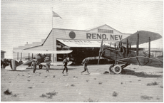
SLC + 437. Reno,
Nev. — The air mail field at Reno lies 2 miles west of the city. The main
runway is east and west. The field is marked by a T and wind indicator, and
landing from four ways is unobstructed. Reno is 4,497 feet above sea level.
Whenever possible it is advisable to leave the Reno field on the east-west
runway, taking off to the east. A slight downgrade enables the ship to quickly
obtain flying speed. Just beyond the east edge of the field the ground is
extremely rough and there is a huge ditch here.
RENO TO
SAN FRANCISCO
Miles from Reno
REN
+ 0. Leaving the Reno field
the pilot should head his ship southwest and gain altitude of at least 10,000
feet to pass safely over the Sierras. Practically all of this altitude should
be obtained near the field before starting on the course.
REN + 020. Lake
Tahoe. — The northern edge of Lake Tahoe is 6 miles south of the course.
REN + 025. Truckee.
— On the Southern Pacific near the point where Lake Tahoe Railway joins
the Southern Pacific from the south. Two and a half miles to the northwest of
Truckee lies a very good summertime emergency landing field. All approaches are
clear and a space available for a landing 600 by 2,000 feet. A big boulder
painted white stands on the northwest side of the field and beside it is a
white wind indicator. This field is to be avoided in winter, as snow gathers on
it to a frequent depth of 4 feet. Soon after passing Truckee the Sierras are
crossed. On the direct course 10,000 feet will clear the highest peak, but an
altitude of 15,000 feet should be maintained. The Southern Pacific Railroad
tracks veer to the west and north and from here on to Sacramento are at a
varying distance of 5 to 20 miles north and west of the course.
REN + 065. Colfax. — Seventeen miles northwest
of the course on the Southern Pacific Railroad. Elevation here is 2,422 feet. A
small level field lies one-half mile south of the city. The field should be
used only in an emergency, as it is difficult to get into and during the rainy
season is very soft. The field is 600 by 300 feet.
REN + 085. Shingle Springs. — Seven miles
south and east of the course, on the Placerville Branch of the Southern Pacific
that runs from Placerville to Sacramento. There is a field here one-half mile
west of Shingle Springs, bounded on the north by a highway running to Placerville
and on the south by the Southern Pacific tracks. The field is 1,500 yards long
north and south and 300 yards wide east and west. The ground is level, hard,
and smooth. The elevation here is approximately 1,000 feet.
REN + 095. The Southern Pacific, running from Placerville
to Sacramento, is crossed at right angles 1 mile southeast of where it makes a
right-angular bend and approximately parallels the course for the next 15
miles. The course lies from 1 to 3 miles southeast of this track.
REN + 0112. Mather Field. — Is the
Army Air Service station in the Sacramento Valley, equipped like all Air
Service flying fields. It is located to the east of Sacramento and near the
small siding called Mills, 2 miles north and east of the course. A huge white
water tower serves as an excellent landmark as well as the three lines of
buildings on the ground. Three railroads are crossed in a stretch of less than
10 miles soon after leaving Mather Field. The Southern Pacific Railroad is to
the northeast of the course at a varying distance of 10 to 15 miles after
leaving Mather Field. Southwest of the course the Sacramento River will be seen
soon after crossing the three railroad tracks at a distance of 5 to 10 miles.
REN + 0152. Suison [Suisun] Bay. —
Into which the Sacramento River empties, a large oblong body of water parallel
to the course. The pilot will fly along the southwest side of this bay.
REN + 0162. Martinez. — On the
southeast corner of Suison bay. One mile northwest of the course.
REN + 0177. Durant Field, Oakland, Calif.
— On the eastern side of San Francisco Bay. The field runs almost due
east and west and has a hangar, wind indicator, and T laid out on it. By coming
in from the east over the hangar an unobstructed run of about 2,000 feet is
obtained. North and south the field is rather narrow and somewhat rough. All
supplies necessary for reservicing a ship may be obtained here. From here fly
directly across San Francisco Bay. The course goes directly over Alcatraz
Isla nd, covered with white Government buildings. Goat Island, larger than
Alcatraz, and more irregularly shaped, on which is located the Naval Station to
be seen to the south.
nd, covered with white Government buildings. Goat Island, larger than
Alcatraz, and more irregularly shaped, on which is located the Naval Station to
be seen to the south.
REN + 0187. Marina Field. — Is
stationed on the south of San Francisco Bay, 3 miles from the Golden Gate, on
the east portion of the old fair grounds. It can be identified by the Palace of
Fine Arts Building, which has a large dome roof, at the west end of the field; a
monument 150 feet high, the Column of Progress, is on the north side of the
field. The city of San Francisco is to the south. There is a prevailing
southwest wind here. A double line of wires borders the eastern edge of the
field and this, in conjunction with the gas plant in the same vicinity, force
the pilot to come in high. The pilot should hold the ship off until the runway
is reached coming in either direction, as both the east and west edges of the
field are very rough. Landings should not be attempted from any direction other
than the east and west.
 The Post Office Flies the Mail, 1918-1924
On August 12,
1918, the Post Office Department took over airmail service from the U.S. Army
Air Service (USAAS). Assistant Postmaster General Otto Praeger appointed
Benjamin B. Lipsner, who left the USAAS, to head the civilian-operated Air Mail
Service. He would remain only until December 6, when he resigned over what he
felt were wasteful and “unnecessary expenditures.” One of Lipsner's first acts
was to hire four pilots, each with at least 1,000 hours flying experience,
paying them an average of $4,000 per year. The department also abandoned the
polo grounds in Washington, D.C., and moved north to the larger airfield at
College Park, Maryland, where it would begin its route to Philadelphia.
The department
used mostly World War I surplus de Havilland DH-4 aircraft, which were
flimsy and not designed for long cross-country flights. Another popular plane
was the Standard Aircraft Company JR-1B, which could carry 300 pounds (136
kilograms) of mail as well as 60 gallons (227 liters) of fuel. During 1918,
including the initial four pilots, the Post Office hired 40 pilots, and by
1920, they had delivered 49 million letters. In its first year of operation,
the Post Office completed 1,208 airmail flights with 90 forced landings. Of
those, 53 were due to weather and 37 to engine failure. The Post Office also
bought the German-made Junkers F 13, which it renamed the
J.L.6 after John Larsen, who had imported it to the United States. The postal
service had high hopes for this all-metal plane, but it proved ex tremely
dangerous and was removed from service after several pilots were killed in
fiery crashes.
tremely
dangerous and was removed from service after several pilots were killed in
fiery crashes.
Postal aircraft
could fly with sacks of mail for an average cost of $64.80 for each hour in the
air. Pilots received a base pay of about $3,600 per year and then were paid
five to seven cents more for each mile they flew, flying an average of five to
six hours each day. After a year in operation, postal revenues for the year
totaled $162,000. The cost to fly the mail had been just $143,000. This first
year of operation was to be the only time in airmail history that the service
showed a profit.
The largest
airmailcustomers were in the banking business. They used the service to send
checks and financial papers more quickly. Bankers wanted to reduce the float
time of checks and pushed for an extension of routes. Financial papers were
light, and the cost to send them was low—just 16 cents an ounce, having
been reduced from 24 cents in July 1918 to attract more customers. It was
further reduced to six cents per ounce on December 15, in an effort to draw
even more customers. In July 1919, the extra charge for airmail was eliminated
completely and airplanes began to carry a random selection of mail. The charge
would be reinstated in 1924 when regular transcontinental service began.
International
airmail delivery began on March 3, 1919, when Bill Boeing and Eddie Hubbard carried
60 letters from Vancouver, Canada, to Seattle, Washington, in a Boeing Model C.
Later that year, Hubbard began flying a Boeing B-1 flying boat for airmail
delivery between Seattle and Victoria, British Columbia. He would continue
flying the plane for eight years—amassing more than 350,000 miles
(563,270 kilometers).
Flying conditions
were poor, and the pilots were forced to fly in all kinds of weather. Praeger,
who didn't know how to fly, was unyielding about keeping the mail on schedule
in spite of the risk, hoping that it would make the public trust the service more.
Tragically, of the 40 pilots hired when the Post Office took over airmail
operations, at least half had died by 1920, most from weather-related crashes.
In July 1919,
pilot Leon Smith refused to fly the mail from New York to Washington, D.C.,
because of rain, clouds, and visibility of only 200 feet (61 meters). Praeger
ordered him to make the trip anyway, using only his magnetic compass to
navigate. Smith and his fellow pilot E. Hamilton “Ham” Lee refused to fly in
the dangerous weather. Both pilots were fired and then, all the pilots in the
airmail system went on strike. After three days of talks, the pilots and
managers agreed to require field managers to make a flight check in bad
weather. The field managers could either fly the inspection themselves or if
they were not pilots, could sit in the mail bin in front of the pilot. The
flight would continue only if the field manager said weather conditions were
safe for flying.
Postal planes
began flying across the country on September 8, 1920. But these flights took
place only in daylight because pilots relied on visual landmarks to navigate.
Each night, the mail would be loaded onto railcars and would travel overnight
until daylight allowed another plane to take over. Rugged terrain and poor
weather, especially in the West, combined with unreliable planes to slow the
service. The service was criticized for being uneconomical and unsafe. Praeger
decided to demonstrate how far airmail had come by flying across the country by
day and by night. On February 22, 1921, pilot Jack Knight helped to change the mix
of railroads and aircraft and give airmail service more status during a test of
transcontinental airmail.
As part of a relay
team of pilots from San Francisco to New York, Knight was scheduled to carry
the mail only part of the way, but a snowstorm in Chicago delayed all the other
pilots. Knight flew the mail from North Platte, Nebraska, all the way to
Chicago, though normally other pilots waiting at stations would have split the
trip. Much of Knight's flying was by night in the bitter cold. He found his way
by looking for bonfires and flares lit by helpers on the
ground. After 830 miles (1328 kilometers), Knight finally connected with his
relief pilot in Chicago. When the last man in the relay reached New York, the
total time to carry the mail had been 33 hours 20 minutes—compared to
four and a half days by train. This was Praeger's final triumph before he was
replaced in April when the administration changed.
Progress continued
to be made. By November 1921, 10 radio stations were installed along the New
York-San Francisco routes to transmit weather forecasts. Soon, parachute flares
were installed in the undercarriage of aircraft to light emergency fields.
Flashing beacon lamps or searchlights were mounted on towers all across the
United States 10 to 30 miles (16 to 48 kilometers) apart depending on the
terrain. Most pilots still flew about 200 to 500 feet (60 to 152 meters) above
ground level so they could navigate by roads and railways. By the end of 1921,
98 airmail planes were in service. In 1922, Tex Marshall helped form the Air
Mail Pilots Association and became its president. On July 16, 1922, the Air
Mail Service could brag that it had completed one year of flying without a
fatal accident. In February 1923, the service was awarded the Collier Trophy for its achievements.
Regularly
scheduled transcontinental service began on July 1, 1924, using pilots leaving
from both the East and West coasts. The pilots also began regular night
flights. They were guided by a lighted transcontinental airway with rotating
beacons and brightly lit emergency landing fields along the way, and they timed
their night flying so as to reach the end of the lighted airway by daybreak.
They tested the new gyroscopic needle to indicate whether
aircraft wings were level and altimeters to show if the aircraft
was climbing or descending. The Post Office resumed using special airmail
postage, which it had discontinued in 1919. Airmail now cost eight cents to
travel in any of the three zones comprising the transcontinental route and
could travel all across the country for 24 cents. By the end of 1924, airmail
planes were routinely completing the New York to San Francisco route within 34
hours.
Sources:
Bruns, James H. Mail on the Move. Polo, Illinois:
Transportation Trails, 1992.
___________. Turk Bird--The High-Flying Life and
Times of Eddie Gardner. National Postal Museum, Washington, D.C.: Smithsonian
Institution Press, 1998.
Chaikin, Andrew. Air and Space--The National Air
and Space Museum Story of Flight. Boston: Bulfinch Press/Little, Brown and
Company, 1997.
Christy, Joe, Wells, Alexander T. American
Aviation--An Illustrated History. Blue Ridge Summit, Pa.: Tab Books Inc., 1987.
Ethell, Jeffrey L. Smithsonian Frontiers of Flight.
Washington, D.C.: Smithsonian Books, New York: Orion Books, 1992.
Jackson, Donald Dale. Flying the Mail. Alexandria,
Va.: Time-Life Books, 1982.
Leary, William M. Aerial Pioneers – The U.S.
Air Mail Service, 1918-1927. Washington, D.C.: Smithsonian Institution Press,
1985.
Smith, Henry Ladd. Airways: The History of Commercial
Aviation in the United States. New York: Russell & Russell, Inc. 1965.
Further Reading:
Boughner, Fred. Airmail Antics. Sidney,
Ohio: Amos Press Inc., 1988.
Heppenheimer, T.A. Turbulent Skies; The History
of Commercial Aviation. New York: John Wiley & Sons, 1995.
Holmes, Donald B. Airmail, An illustrated
History 1793-1981. New York: Clarkson N. Potter Inc., 1981.
Lipsner, Benjamin B. The Airmail Jennies to Jets.
As told to Leonard Finley Hiltsd. Chicago: Illinois, Wilcox and Follett
Company, 1951.
Shamburger, Page. Tracks Across the Sky. New York:
J.B. Lippincott Company, 1964.
http://www.centennialofflight.gov/essay/Government_Role/1918-1924/POL3G8.htm