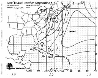
Pattern 1 - Fast moving Low Pressure and Cold Front Overruns East Coast and Western Atlantic
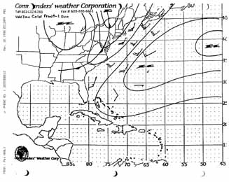
Map: Cold Front - 1
-
Bermuda High extends from Bermuda ENE towards the Azores.
-
Close to the axis of High Pressure winds will drop to less than 10 kts.
-
Closer to the front, S to SW winds 15-20 kts S of 35N and 20-30 kts N of 35N as Cold Front pushes up against the High Pressure and compresses the isobars.
-
Max winds usually occur when wind reaches 210-230 degrees.
-
Squall Line may precede Cold Front by 10 - 50 miles (20 min to 2 hrs.) Max winds in Squall approximately height of Cumulonimbus clouds in 1,000 ft. 45,000 ft squall lines produce gusts to 45 kts
-
Behind the front cool dry NW'ly winds initially strong but dying as front moves E'ward.
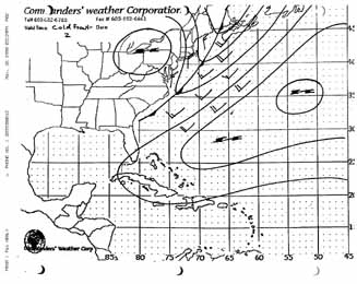
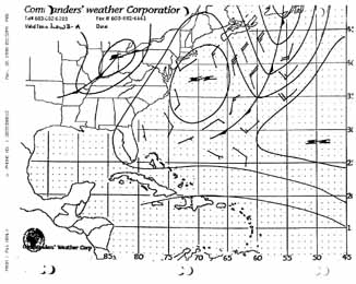
Map: Cold Front - 2
-
As Cold Front moves offshore and approaches the Gulf Stream it will try to split the Bermuda High. The W'ern piece is pushed WSW towards the Bahamas while the E'ern portion moves into the North Atlantic.
- The more the Cold Front is orientated N/S (rather than NE/SW) the stronger the preceding winds. Max wind speed still at 210-230 wind direction.
- Strongest winds behind the front from 310-330.
- If the temperature behind the front is cooler than the Gulf Stream, warm air will rise and cause mixing and the wind speed will increase significantly and become very gusty.
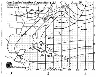
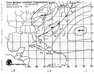
Map: Cold Front - 3
- As the Low Pressure moves to the E the trailing Cold Front lags behind, rotates to become more E/W and slows. The front often either stalls or dissipate before reaching Bermuda.
- Cold Front becomes more of a wide, transition zone and wind speed drop considerably.
- N of the front the winds will be E and NE.
- S of front the winds will be stronger and W'ly.
- As the two air masses on either side of the front mix the boundary breaks down and the winds becomes light and variable.
- Finally the Bermuda High regains its control of the area and awaits the next challenge from the west.
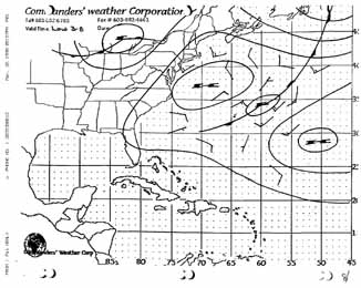
Pattern 2 - Slow moving Low Pressure and Cold Front Stalls at the coast and a small Low Pressure "Wave" moves up the Cold Front.
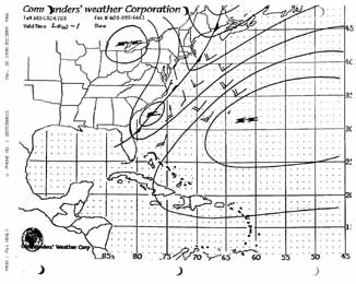
Map: Low - 1
- Same picture as above but the Cold Front is moving very slowly or almost stopped.
- A small, secondary Low (or Wave) forms on the front and moves N'ward.
- Maximum wind speed will be between the newly formed Low and the Bermuda High with a direction of 180-200.
- A second max wind area will be on the NW corner of the Bermuda High parent Cold Front. Wind direction here is 210-230.
- Just ahead (NE) of the newly formed Low the winds will be pulled around to 140-160.
- Behind the newly formed Low wind speed will increase rapidly.
There are two equally likely scenarios that may play out.
- Scenario A -- The main Low Pressure system stalls and the newly formed Low takes control and moves up the Cold Front to the NE resulting in stronger, maybe Gale Force winds.
- Scenario B -- The main Low Pressure regains momentum and pulls the newly formed Low along to the ENE.
Map: Scenario A - 2 New Low Takes Control
- The rapidly intensifying Low moves up the Cold Front and pushes up against the Bermuda High pushing it slowly ENE.
- The resulting N/S oriented Cold Front with strong winds between 180 - 220. However, watch for winds as far right as 160 to the NE of the Low.
- W of the Low the strongest winds will be in the NW quadrant and from 300-330. These winds will drop quickly when the wind backs beyond 290.
Map: Low - Scenario A - 3 New Low Takes Control
- The Low will intensify as it moves N causing the winds to increase and the trailing H Pressure to be pulled in behind the advancing Cold Front.
- Although this looks like the Bermuda High has split it is two different air masses. The W'ern High Pressure is cool and dry while the E'ern is the warm and humid "real" Bermuda High.
- Strong NW/N'ly winds between the High and the rapidly moving Cold Front will drop rapidly. (The longer the Cold Front stays oriented N/S the longer the winds will strong winds will hold.)
Map: Low - Scenario B - 2 Main Low Regains Momentum
- Above 37N the main Low Pressure regains control and moves E'ward dragging the newly formed Wave with it.
- The "baby" Low and is now sandwiched between two Highs.
- If Low passes to the N, winds will back from 090 through 180 towards 225. If the Cold Front passes the winds will continue to 320 then die. If you are too far south, the winds will begin to die at 225
- If Low passes to the S, winds will veer from 090 to 320-340 and begin to die..
Map: Low - Scenario B - 3 Main Low Regains Momentum
- Wind will veer back to the E as Cold Front and Low Pressure moves to the E and next High Pressure drops into the W'ern Atlantic.
- Winds will drop as Cold Front begins to orientate more E/W.
- Wind will shift from E'ly to W'ly if you sail through the stalled E/W Cold Front.
Pattern 3 - Back Door (Comes from NE instead of NW) Cold Front.
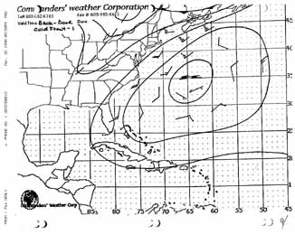
Map: Back Door Cold Front - 1
- Bermuda High stronger than normal (center pressure 1024mb or higher) and centered just N of Bermuda.
- and a second strong Canadian High is pushing SE'ly out of Quebec and Labrador.
- Strongest winds are at the front separating the two air masses.
- Exception to the N/S-E/W front orientation rule. Strongest winds 210-230 and will drop as wind veers past 230.
- Canadian High spreads out as it pushes SE causing the Cold Front to push into the W'ern Atlantic from the NE rather than the NW (hence - Back Door)
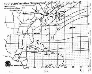
Map: Back Door Cold Front - 2
- A small Low Pressure "Wave" forms along the S'ward moving Cold Front reinforcing the warm and humid SW'ly wind and allowing thunderstorms to develop.
- As cold front passes winds will veer further than the typical "320 and die" of a "normal" Cold Front passage.
- Winds will finally drop quickly when direction reaches NE
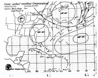
Map: Back Door Cold Front - 3
- As the Low Pressure "Wave" moves NE, the trailing High Pressure is forced S and the Cold Front continues to move SW down the East Coast.
- Winds in front of the Cold Front will be NW and switching to the ENE and E as the Cold Front passes.
- Winds become light and variable as the three High Pressure systems coalesce.
- Next wind field will approach from the W but patience will be tested.